
Before imbibing this Bellmont chronicle, recall: bellows blow, barges drift, and statistics swell like lungs in March. Proceed, but tether your skepticism, lest the genteel hot air waft you lakeward unawares this evening.
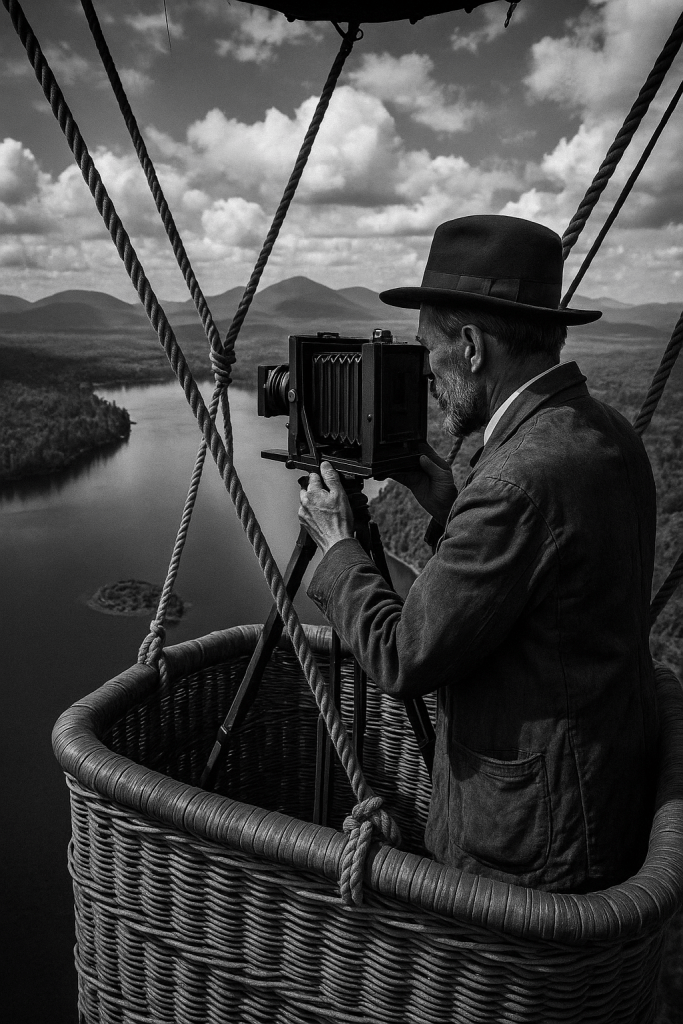
In the spring of 1901—two years before the Delaware & Hudson Company would absorb the Chateaugay enterprise—Smith M. Weed ordered a final synoptic inspection of his ore and timber domain. Ever the modernizer, Weed engaged Melvin D. Jones of Plattsburgh, an early practitioner of tethered‑balloon photography, to expose a suite of 8×10‑inch dry‑plate negatives over Lower and Upper Chateaugay Lakes. Though balloon surveys were still experimental, Jones’s plates captured a broad lattice of overlapping images, each one etched with the date, compass bearing, and altitude in a fine copperplate hand. Weed’s intention was practical—he sought a visual inventory of standing timber and charcoal kilns to buttress his asking price in negotiations with the Delaware & Hudson board. Yet the glass plates, boxed and forgotten when D&H took control in July 1903, came to light only in 2023 during an estate sale outside Plattsburgh.
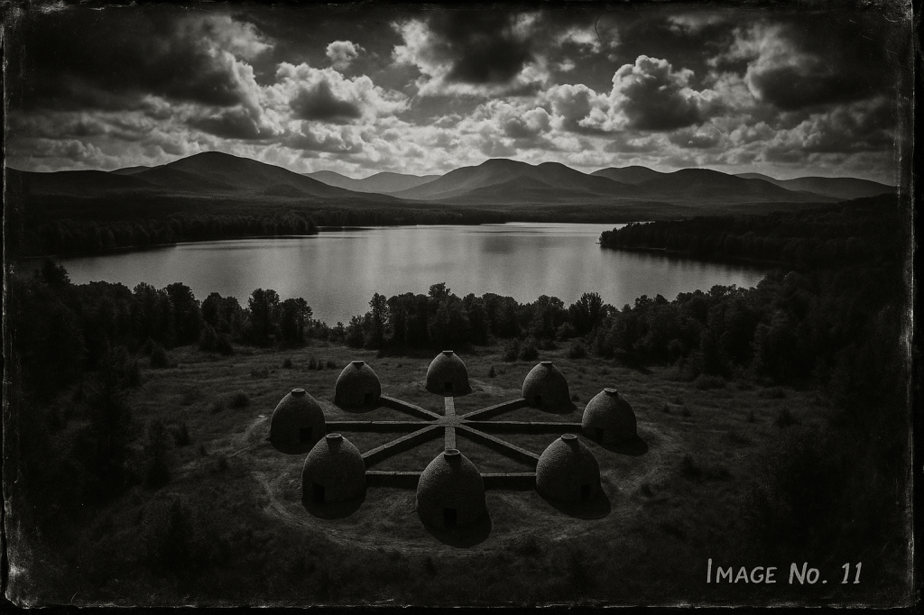
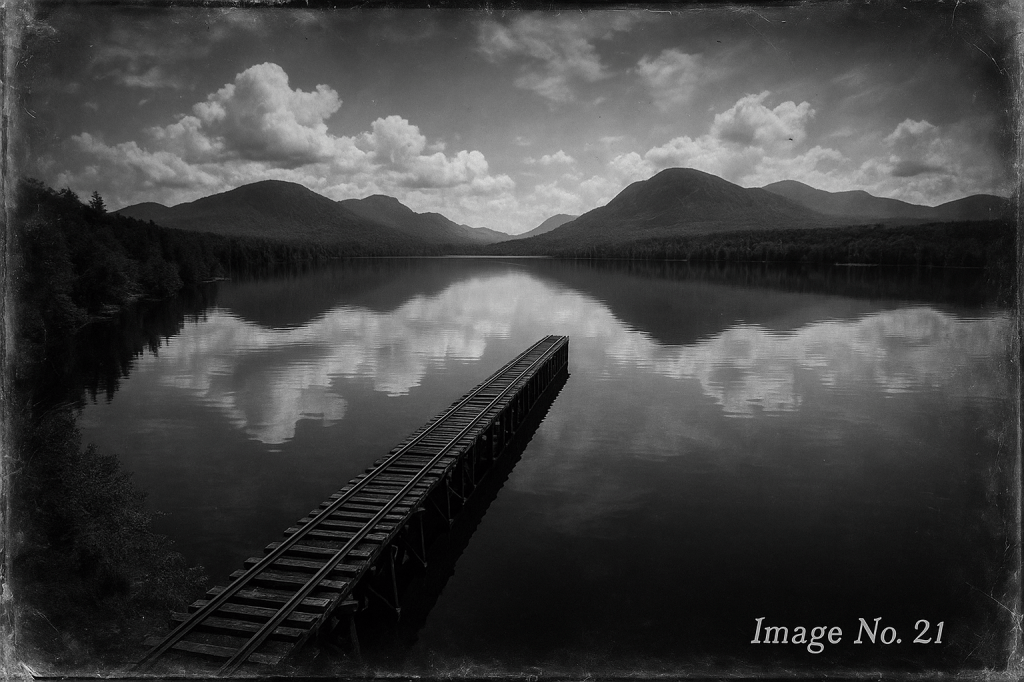
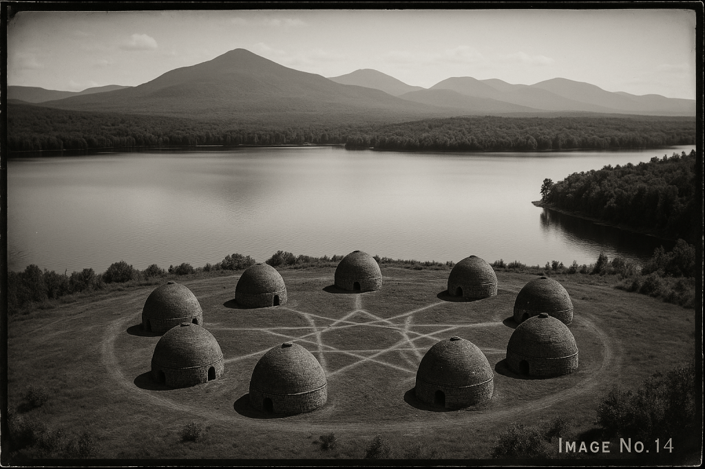
Their contents startled archivists. On Image № 14, just south‑west of Popeville, stands a circular kiln complex never shown on surveyor George Platt’s 1896 map: eight beehive kilns linked by masonry flues into a perfect heptagram—a design more alchemical than industrial. Plate № 21 reveals a narrow‑gauge spur running straight off the timber trestle and vanishing into the mirrored surface of Lower Chateaugay Lake, as though the track were laid for barges rather than locomotives. Most unsettling is Plate № 25: the faint shadow of a second timber crib‑and‑rock dam buried under water, half a mile below the known outlet dam, its angled spillway pointing not down‑river but east toward Figure Eight Mountain.

The 2024 Resurvey and Its Disquiet
Intrigued by the anomalies, the Adirondack Mapping Cooperative dispatched a four‑person LIDAR and ground‑penetration crew in May 2024 to retrace Jones’s aerial grid. Their base camp—pitched on the Popeville mill‑race—reported equipment irregularities from the outset. Total‑station gyros drifted; handheld compasses rotated with leisurely indifference; and every photograph taken after dusk registered a pale emerald corona around the campfires. Crew chief Clara Renzo, P.L.S., noted in her log that green tongues of flame rose whenever sparks settled on soil evidently rich in charcoal fines.

The team located moss‑cloaked stone arcs matching the supposed heptagram kiln ring, but ground‑penetrating radar returned “voids of indeterminate depth” beneath each locus. Surveyor Luke Sorrell sank a stainless probe six feet before it struck a cool cavity that exhaled balsam‑scented air—as if the kiln chambers still breathed. At lake‑edge, bathymetric scans confirmed a cribwork structure fourteen feet below present pool level—precisely where Jones’s Plate № 25 suggested. Timber samples, raised with grappling hooks, showed axe‑marks consistent with late‑1870s crib construction yet were coated in an anomalous verdigris sheen.
While the Cooperative’s official report cites “magnetic disturbance from residual slag and magnetite fines,” Renzo privately wondered whether Weed’s engineers had “laid something beneath the lake meant never to be found.” Her closing note, scribbled in the margin: “Needles spin worst at night tide; perhaps the ore remembers its furnace.” Camp was struck after a final incident in which the GPS base‑station flashed error codes spelling, by sheer coincidence or cipher, the letters P O P E V—then failed outright. The field crew departed at first light, leaving only faint green ash circles amid the ferns, like mute epilogues to a survey conceived in ambition and concluded in perplexity.


What mysteries of Chateaugay Lake haunt you?